


Lares Trek: Is It the Right Route to Machu Picchu for You?
The Lares Trek is a 4 or 5-day route that crosses the Lares Valley and connects with Machu Picchu at the end of the journey. Unlike the Inca Trail, it does not require a special trail permit, although it does require booking the Machu Picchu entrance ticket and the trains to Machu Picchu Pueblo (Aguas Calientes) well in advance. The highest point on the classic versions reaches Sicllakasa Pass, at 15,846 ft (4,830 m), usually on the second day.
What gives this route its character is connection with Quechua communities in the puna and upper valley, real herding life, textiles still in use, trails without continuous tourist signage.
Table of Contents
Some routes lead to Machu Picchu, and some routes make you look at the territory surrounding it first. The Lares Trek belongs to that second group. It crosses an inhabited valley northeast of the Sacred Valley, climbs through pasturelands and puna trails, passes through high-altitude Quechua communities, and makes clear from day one that the mountain here was not arranged with the visitor in mind.
| 4 or 5 daysduration depending on version | 19 to 25 mitotal distance (31 to 41 km) | 15,846 ftmaximum elevation (4,830 m) |
| 10,334 fttypical start at Pumahuanca (3,150 m) | No trail permitbut entrance ticket and train must be booked | Multiple variantsdepending on community, operator |
Compared to the Inca Trail, with its archaeological weight and restricted daily permits, and to the Salkantay, with its glacial pass at 15,216 ft (4,638 m) and descent into cloud forest, the Lares Valley route offers a different relationship with the Andes. In its classic version, the hike ends at the Lares hot springs, then connects with Ollantaytambo and the train to Machu Picchu.
Keep reading to see whether this route genuinely fits your body, your schedule, and the kind of experience you’re looking for in Cusco.
Important note:
The Lares Trek makes sense for travelers who handle altitude reasonably well, prefer small groups, and want an experience where the human environment still carries weight. If you’re drawn to crossing communities, puna, lakes, textiles, and an open mountain rhythm, this hike fits that kind of travel well.
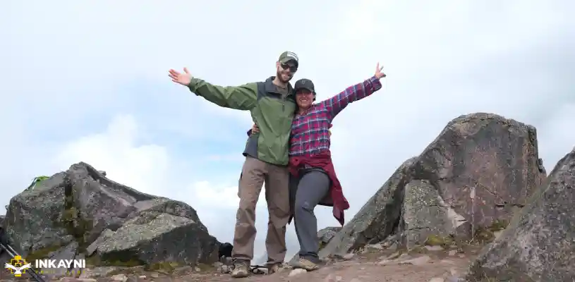
The Lares Trek crosses an inhabited mountain corridor. The trails connect communities, grazing areas, gorges, and high passes before linking up with the rail network toward Machu Picchu.
What the Lares Trek is and why it remains a serious alternative
The Lares Trek was not designed as a tourist route. The trails that trekking groups use today were already connection paths between Andean communities like Cancha Cancha, Cuncani, Quishuarani, Pumahuanca, and Lares. They served to move people, livestock, textiles, agricultural goods, and relationships across different ecological zones. Several segments run alongside long-established Andean networks, though the route as a whole does not function as a monumental archaeological corridor like the Inca Trail.
The Lares hike established itself as one of the alternatives for those who cannot get a spot on the Inca Trail or simply prefer not to join the more crowded route.
PERU’S LEGENDARY HIKEInca Trail to Machu Picchu
Follow the historic trail through mountain passes, Inca sites, and cloud forest paths to Machu Picchu.
Did you know?
The route requires no special permit to walk, but visiting Machu Picchu does depend on a valid ticket, an assigned circuit, and a fixed entry time. If you’re traveling in high season, don’t leave the entrance ticket or the train to the last minute. When online sales are sold out, there is still a limited walk-up contingent in Machu Picchu Pueblo for the following day, but relying on that adds friction and dead time to the trip.
The most common versions of the Lares Trek
Inkayni Peru Tours operates two main versions. The difference is not only in duration. It changes how the arrival at Machu Picchu is handled, and with that, the tone of how the journey closes.
| Lares Trek 4D / 3N | Lares Trek + Short Inca Trail 5D / 4N | |
| Total distance | 19 mi (31 km) | 25 mi (41 km) |
| Maximum elevation | 15,846 ft (4,830 m) | 15,846 ft (4,830 m) |
| Arrival at Machu Picchu | Bus from Machu Picchu Pueblo | On foot via Intipunku, subject to Short Inca Trail availability |
| Additional sites | Not applicable | Chachabamba, Wiñay Wayna, and Intipunku on the Short Inca Trail segment |
| Hot springs | Yes, day 3 | Yes, day 3 |
| Best for | Those who want the full Lares Valley experience with a simpler logistical close. Those who also want to walk into Machu Picchu and add an archaeological segment to the trip. |
|
That shows in the experience of walking it. The route crosses puna, wetlands, high-altitude lakes, small queña woodlands, and villages where genuine communal life still exists. Signage is not continuous, variants shift depending on the operator and season, and the terrain can change significantly with rain or frost.
Day-by-day itinerary for the 4D / 3N version
This is the classic 4-day Lares Trek itinerary. The elevations, distances, and times are there to help you understand how much each day demands and how the route is organized on the ground. More than filling out the page, they help you read which part of the trek taxes the lungs, which one loads the legs, and where logistics start to matter as much as the walking itself.
Day 1 · Cusco – Pumahuanca – Puyoc
Cusco – Pumahuanca – Puyoc
| Route | Cusco (11,155 ft / 3,400 m) – Pumahuanca (10,334 ft / 3,150 m) – Puyoc (14,108 ft / 4,300 m) |
| Distance | Approx. 6.8 mi (11 km) |
| Hiking time | 5 to 6 hours |
| Camp | Puyoc, 14,108 ft (4,300 m) |
| Meals | Lunch and dinner |
| Along the way | Pumahuanca archaeological site, waterfall near Puyoc, puna grasslands |
The first day starts with a transfer from Cusco to Pumahuanca, typically around 1 hour 30 minutes. From there the trail climbs steadily through a valley that still holds transitional vegetation before opening into the puna. The ground alternates between dirt, rock, and sections where the gradient taxes the lungs more than any technical difficulty. What matters here is not just the distance. The key factor is that camp sits at Puyoc, at 14,108 ft (4,300 m). That first night tends to fragment sleep, dry out the throat, and make the pulse more noticeable. At altitude, that is within the expected range.

Day 2 · Puyoc – Sicllakasa Pass – Yanacocha Lakes – Cuncani
Puyoc – Sicllakasa Pass – Yanacocha Lakes – Cuncani
| Route | Puyoc (14,108 ft / 4,300 m) – Sicllakasa (15,846 ft / 4,830 m) – Yanacocha – Cuncani (12,467 ft / 3,800 m) |
| Distance | Approx. 7.5 mi (12 km) |
| Hiking time | 7 to 8 hours |
| Maximum elevation | 15,846 ft (4,830 m) at Sicllakasa Pass |
| Camp | Cuncani, 12,467 ft (3,800 m) |
| Meals | Breakfast, lunch, and dinner |
| Along the way | Sicllakasa Pass, Yanacocha lakes, wetlands (bofedales), alpacas, open puna sections |
The second day defines the route. The climb from Puyoc to Sicllakasa Pass concentrates the greatest aerobic demand of the trek. Here the body calls for a different pace. Pushing too hard tends to show up as headache, elevated heart rate, and accumulated fatigue. If the sky opens up, the pass offers a clear reading of the high-Andean landscape in layers: dark lakes, dry slopes, patches of snow, and grasses that change tone with the season. The descent toward Cuncani eases the breathing considerably and helps make the second night’s sleep more restful.

Important note:
Sicllakasa Pass sits well above the maximum elevation of the classic Inca Trail. Acclimatization matters more here than enthusiasm. Two full nights before the trek help significantly. Even better if one of them is in the Sacred Valley. If you experience intense headache, persistent nausea, disorientation, or shortness of breath at rest, the guide needs to know immediately. At altitude, early correction is the right call.
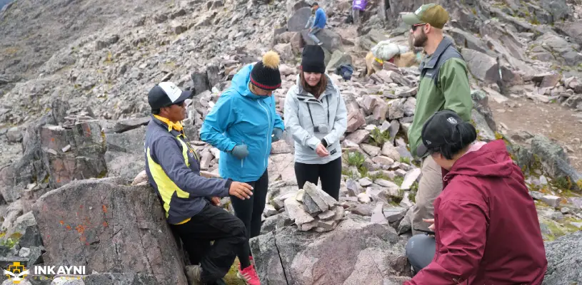
Sicllakasa Pass, at 15,846 ft (4,830 m), concentrates the most demanding section of the trek. At that elevation, hiking depends on pace, acclimatization, and reading the body.
Day 3 · Cuncani – Lares – Ollantaytambo – Machu Picchu Pueblo
Cuncani – Lares – Ollantaytambo – Machu Picchu Pueblo
| Route | Cuncani (12,467 ft / 3,800 m) – Lares (approx. 10,334 ft / 3,150 m) – transfer to Ollantaytambo – train to Machu Picchu Pueblo |
| Hiking | Approx. 5 mi (8 km), 3 to 4 hours |
| Meals | Breakfast, lunch in the Lares area, and dinner in Machu Picchu Pueblo |
| Along the way | Upper valley crops, Lares hot springs, puna-to-agricultural-zone transition, town of Ollantaytambo |
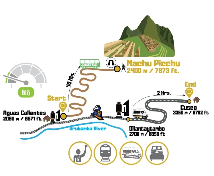
The third day shifts the tone of the route. The descent brings the trail into a more inhabited setting, with small plots of land, more visible water, and air that is noticeably less dry. In Lares, the hot springs typically run between 97 and 111°F (36 to 44°C). The facilities are simple and work well for what they are. After two days of cold, altitude, and muscular accumulation, the warm water helps release the legs and back before the transfer to Ollantaytambo and the train. From Ollantaytambo, the rail journey to Machu Picchu Pueblo typically takes between 1 hour 30 minutes and just over 2 hours, depending on the service and operator.
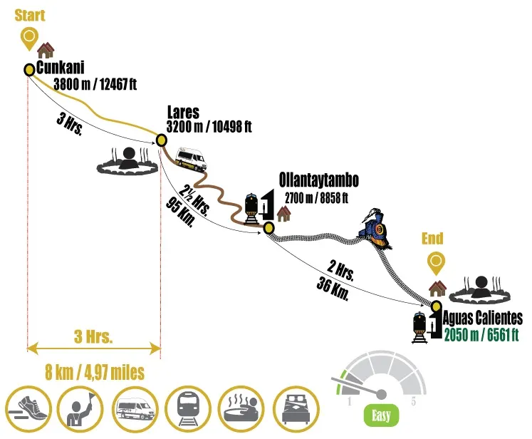
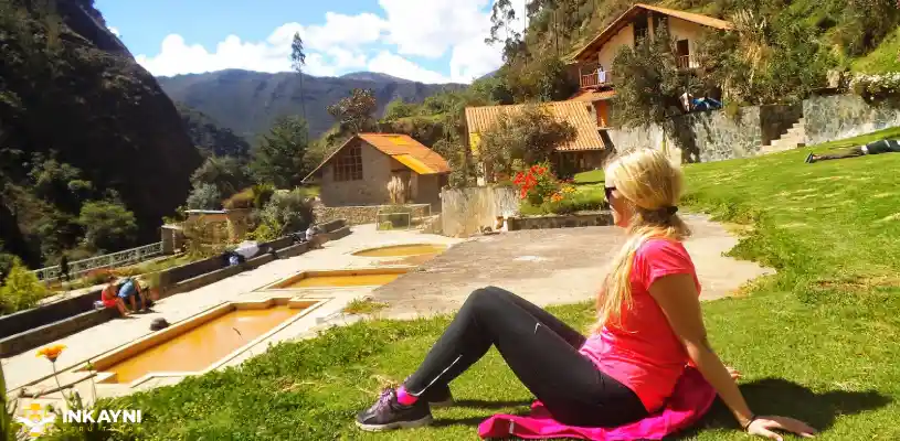
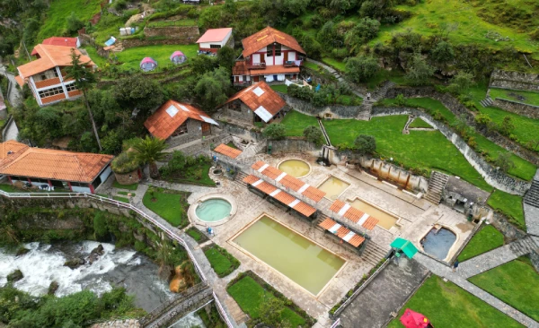
The Lares thermal baths bring a logical close to the walking portion of the route. After the pass and two nights at altitude, the warm water serves a concrete function for the body.
Day 4 · Machu Picchu and return to Cusco
Machu Picchu and return to Cusco
| Route | Machu Picchu Pueblo – bus to Machu Picchu (7,972 ft / 2,430 m) – train to Ollantaytambo – transfer to Cusco |
| Bus transfer | 25 to 30 minutes each way |
| Included tour | Guided visit on the assigned circuit, per current regulations and ticket availability |
| Meals | Breakfast included. Lunch on your own in Machu Picchu Pueblo or Ollantaytambo. |
The last day no longer depends on trekking but on logistics. The bus between Machu Picchu Pueblo and the entrance to the llaqta normally takes 25 to 30 minutes. The visit is organized by assigned circuit and route based on the ticket issued. That is worth being clear on before you arrive. The experience remains compelling, but today it is far more conditioned by operational rules. It is worth reviewing carefully which circuit you have and how much time it allows inside.
Other Guides That Help Before Booking the Lares Trek
If you are still weighing altitude, route style, Sacred Valley logistics, and the final connection to Machu Picchu, these guides help you see where the Lares Trek fits best.
Other Lares Trek Variants
The Lares Trek does not work in practice as a single fixed route. It is better understood as a group of mountain corridors that change according to the trailhead, the community where you camp or spend the night, the pass you cross, and how the final connection to Ollantaytambo and Machu Picchu is organized.
3-day short version with Machu Picchu connection
Some departures cut one hiking day and compress the valley experience into less time. They still include the passage through high-altitude communities and the final link to Machu Picchu, but reduce the walking portion compared to the classic 4-day version. This tends to fit travelers with tighter schedules.
Independent 2 or 3-day version without Machu Picchu
There are also itineraries that end within the Lares circuit itself, without continuing to the llaqta. In those versions, the weight of the trip falls entirely on the walking, the communities, the lakes, and the high-Andean landscape. It makes sense for travelers who already visited Machu Picchu or want a shorter route less dependent on trains and entrance tickets.
Variant via Huaran and Cancha Cancha
This is one of the best-known alternatives to the classic route that enters via Pumahuanca and descends toward Lares. The corridor is organized around Huaran, Cancha Cancha, and the passes that connect to other high communities. It gives more weight to the upper side of the Sacred Valley and to camping within a living community.
Variant via Quishuarani, Huacahuasi, and Yanahuara
Another family of itineraries enters more directly through villages in the Lares Valley, usually organized around Quishuarani, Huacahuasi, or Yanahuara. Here lakes, waterfalls, wetlands, and the textile work of communities known for their weaving traditions tend to have a stronger presence. Compared to Inkayni’s classic version, the main difference lies in the human corridor you pass through and the point from which the final exit is arranged.
The communities and the human dimension of the route
In places like Cuncani or Cancha Cancha along the Lares Valley route, daily life is not arranged around the visitor. There is still herding, textile work, high-altitude farming, schooling, communal organization, and a grounded relationship with the territory that continues with or without trekking.
That affects the traveler’s experience. Sometimes there is conversation facilitated by the guide. Sometimes there is only respectful observation. You see herds moving, textiles spread out to dry in the sun, stone dwellings with roofs adapted to the climate, children walking distances that would seem long to any visitor, dogs standing guard, women spinning or selling pieces made right there. There is less staging and more reality.
Did you know?
The Lares route has concrete reasons for its association with the textile world. In several communities, weaving remains an active economic and cultural practice. Buying a piece directly on the trail carries more meaning than buying one without context in a store in the historic center.
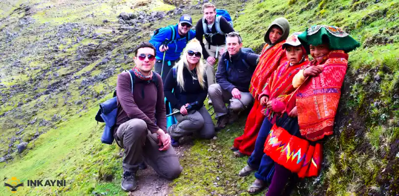
On the Lares hike, the human presence does not appear as decorative backdrop. The route passes through villages where weaving, herding, and communal life continue to organize the territory.
Difficulty and what the body needs to know
The Lares Trek is generally classified as moderate to strenuous. The variable that most changes the experience is altitude. Physical preparation helps, of course. It raises tolerance to effort, steadies the pace, and improves recovery. Even so, a well-trained person can have a hard time if they arrive poorly acclimatized, and a person with average fitness can hike quite well if they arrived with enough time (2 to 3 days before starting the trek), rested properly, and knew how to pace themselves.
| Factor | Specific data | What it means for the trekker |
|---|---|---|
| Cumulative elevation | From 10,334 ft (3,150 m) to 15,846 ft (4,830 m) | The first night and the second day concentrate the greatest altitude stress. |
| Hardest day | Day 2, with 7.5 mi (12 km), 7 to 8 hours, and a pass at 15,846 ft (4,830 m) | A slow pace, proper hydration, and starting well acclimatized make a significant difference in how the day goes. |
| Terrain | Dirt and stone trail, mud in rain, partial signage | Worn-in trekking boots are recommended, along with poles if you tend to lose stability on descents. |
| Nighttime temperature | Between 28 and 41°F (-2 to 5°C) at high camp during dry season | The right sleeping bag is not a luxury. It determines rest and recovery capacity. |
| Technical difficulty | Low to moderate, depending on mud and conditions | The challenge is primarily aerobic, thermal, and altitude-related. No complex technical maneuvers required. |
Who this hike fits best
|
A good fit if…
|
Worth considering another route if…
|
Lares vs. the Inca Trail and Salkantay
| Criteria | Lares Trek | Inca Trail | Salkantay Trek |
|---|---|---|---|
| Typical duration | 4 to 5 days | 4 days (classic version) | 5 days (most common version) |
| Maximum elevation | 15,846 ft (4,830 m) | 13,828 ft (4,215 m) | 15,216 ft (4,638 m) |
| Trail permit | No | Yes, with limited daily quota | No |
| Reasonable lead time | 2 to 3 months to secure Machu Picchu tickets | 6 months in advance | 2 to 3 months to secure Machu Picchu tickets |
| Main emphasis | Communities, lakes, and inhabited high-Andean landscape | Archaeological heritage and walking into Machu Picchu | Glacial mountain, strong ecosystem transitions, and high hiking volume |
| Trail traffic | Low to moderate | Moderate to high | Moderate to high |
| Hot springs | Yes, at the end of the route | No | Yes, depending on variant |
| Best profile match | Those who want to hike with less crowding and a stronger human dimension | Those who prioritize the symbolism and archaeological continuity of the journey | Those looking for higher hiking volume and more dramatic scenery |
| Average price range | USD 570 to 650 | USD 779 to 935 | USD 310 to 695 |
Costs and what a Lares Trek package actually includes
A Lares Trek 4 days with a formal agency typically runs around USD 570 to USD 650 per person for group service, rising for private departures. Most of the cost in a solid package covers the guide, transport from Cusco, camping, meals during the trek, logistical support, the return train, buses, the Machu Picchu entrance ticket, and one hotel night in Aguas Calientes.
| Market reference | Published price | Practical read |
|---|---|---|
| Inkayni | From USD 569 | A solid market entry point for formal group service. |
| Salkantay Trekking | From USD 620 | Already in the mid-range of the established market. |
| TreXperience | From USD 640 | Positions itself higher, with more refined service and upgraded train options depending on the departure. |
| Alpaca Expeditions | USD 650 | Marks the typical ceiling for standard-to-high group service. |
| SAM Travel | USD 537 to 627 | Their range shifts considerably based on group size and configuration. |
| Primary range for reference | USD 570 to USD 650 | The most reasonable benchmark for a Lares Trek 4D/3N at market. |
Important note:
If you see prices clearly below USD 500, it is worth reviewing carefully what is not being included before assuming it is a good choice for your trip.
How far in advance should you book
The Lares Trek does not have the same bottleneck as the Inca Trail because the route does not operate with daily permit quotas. The sensitive point here tends to be something else: the Machu Picchu entrance ticket, the assigned circuit, the entry time, and the train. That is why reasonable lead time is not just about the trek itself, but about how competitive that final stretch of the trip is on the dates you want.
| Travel dates | Reasonable lead time | Practical read |
|---|---|---|
| June, July, August, and high-demand dates such as Easter Week, Inti Raymi, Independence Day holidays, and year-end | 3 to 4 months ahead | If you want good time slots, a reasonable circuit, and a decent train, waiting is not a good idea here. |
| April, May, September, and October | 2 to 3 months ahead | Still a solid window. Leaving it later tends to mean fewer circuit options, worse time slots, and limited train availability. |
| November, early December, January, February, and March, outside of major holidays | 2 months ahead | More flexibility here, but booking ahead still keeps you from assembling the trip from whatever is left over. |
Weather on the Lares Trek
The general pattern of the valley follows the Andean calendar of southern Peru. Between April and October the dry season dominates. Between November and March the probability of rain, mud, fog, and rapid weather shifts increases.
| Month | Typical weather | Day / night temperature | Practical read |
|---|---|---|---|
| January – February | Heavy rain | 50 to 57°F (10 to 14°C) / 39 to 43°F (4 to 6°C) | The trek is possible, but the terrain becomes less stable and slower going. |
| March | Moderate rain, greener hillsides | 54 to 57°F (12 to 14°C) / 41°F (5°C) | Transition month. Fewer people, more moisture on the trail. |
| April | Start of dry season | 55 to 59°F (13 to 15°C) / 39 to 41°F (4 to 5°C) | Strong balance between stability and lower tourist pressure. |
| May – June | Dry and increasingly clear | 54 to 61°F (12 to 16°C) / 30 to 37°F (-1 to 3°C) | Very good window. Cleaner skies and noticeably cold nights. |
| July – August | Dry, cold, higher general tourist traffic in Cusco | 57 to 61°F (14 to 16°C) / 28 to 36°F (-2 to 2°C) | Great hiking weather. Requires earlier booking for trains and entrance tickets. |
| September – October | Dry with gradually increasing cloud cover | 55 to 59°F (13 to 15°C) / 39 to 43°F (4 to 6°C) | Another very good window. Less pressure than July and August. |
| November – December | Start of rainy season | 55 to 59°F (13 to 15°C) / 43 to 45°F (6 to 7°C) | Still doable, with higher probability of wet ground and overcast skies. |
Wildlife, flora, and landscape
The value of the Lares Valley route lies in how it combines high-Andean landscape, communal life, and genuine ecological transitions in a short amount of time.
| Zone or ecological tier | What dominates the landscape | Wildlife and flora you may encounter |
|---|---|---|
| High puna zone, passes, and lakes | Cold lakes, open slopes, rock, ichu grass, wetlands, and a landscape that feels more exposed and mineral in character. | Alpacas, llamas, high-altitude birds, vizcachas on rocky sections, and cold-adapted vegetation built for wind and frost. |
| Elevation-to-valley transition | Gorges, long descents, less open terrain, and a mix of rock, grass, and early agricultural land. | More passing birds, Andean shrubs, transitional vegetation, and depending on the section, some high-altitude trees like the queña. |
| Community and upper-valley sections | Fields, terraces, local roads, corrals, scattered dwellings, and a landscape that is far more worked and inhabited. | Domestic animals, herds, Andean crops, agricultural flora, and common valley birds. |
| Rocky and quiet sections | Rock walls, shade, crevices, dry slopes, and sections where the landscape seems quieter than it actually is. | Vizcachas and some raptors if the section is undisturbed and the group is not making too much noise. |
| Less frequent sightings | Open skies, thermal currents, and specific moments of good visibility. | Condor and other large soaring birds, more as a possibility than a fixed part of the route. |
Did you know?
The Lares hike does not impress through a single iconic mountain or one standout image. Its strength lies in the combination of lakes, altitude, communities, herds, vegetation shifts, and the descent into a more alive and worked landscape. It is a less theatrical route than others, but more human and richer when you know how to read it.
What to actually pack
In most organized services, heavy gear travels by mule and the hiker carries a daypack. That simplifies the experience considerably, but it does not fix preparation mistakes. Packing light does not mean packing wrong. The useful daily weight typically covers water, layers, documents, snacks, sunscreen, and something for rain.
| Category | What to bring | Why it matters |
|---|---|---|
| Documents | Original passport or the ID used for the booking | Required at the train and at Machu Picchu. Must match the ticket. |
| Footwear | Already broken-in trekking boots or trail shoes; light sandals or camp shoes for the afternoon | The classic mistake is debuting new footwear at altitude. The result is blisters and poor footing. |
| Layered clothing | Base layer, fleece, waterproof windbreaker, hat, gloves, dry change of clothes | At altitude weather shifts fast. Layers regulate the body better than one heavy garment. |
| Overnight | Sleeping bag rated to around 14°F (-10°C) comfort, headlamp, portable power bank | Sleeping cold affects recovery. There is no electricity during the camping portion. |
| Health and protection | High-SPF sunscreen, UV-rated sunglasses, lip balm, standard pain reliever, medical tape, personal medication | UV radiation at altitude burns even when the day feels cool. |
| Water and energy | Water bottles or hydration bladder, simple snacks, something salty and something sweet | Appetite can drop at altitude. Having energy within reach matters even when you do not feel like eating. |
The Lares Hot Springs: A Well-Earned Pause
After two days of altitude, cold, and steady physical effort, the Lares hot springs arrive at the right time. The water ranges from 97 to 111°F (36 to 44°C), and that heat helps release tension in the legs, back, and shoulders before the final stretch of the journey. Many trekkers step out feeling looser, warmer, and more recovered than when they got in.
The mineral water adds to that sense of relief after sustained effort. That is enough reason to value the stop. The hot springs are one of the most appreciated moments on the route and help bring the walking portion of the experience to a gentler close before the transfer to Ollantaytambo and the train to Aguas Calientes.
Acclimatization and health at altitude
Cusco sits at 11,155 ft (3,400 m) and Puyoc camp rises to 14,108 ft (4,300 m). If you arrive in Cusco and head out on the trek the next day, the body will not have adapted enough. The most sensible approach is arriving with at least two full nights of margin. The first day should be spent resting. On the second, move gently, drink plenty of water, and eat light.
Mild soroche symptoms typically include headache, heaviness, disrupted sleep, reduced appetite, and excessive fatigue. If repeated vomiting, shortness of breath at rest, confusion, or intense unrelenting pain appears, the priority is to inform the guide and descend. At altitude, going down remains the most important response.
Did you know?
Coca leaf, in candies or infusions, can ease mild symptoms but does not replace acclimatization, sleep, or hydration.
Logistics, trains, tickets, and how the end of the trip comes together
- The Lares Trek is typically organized with camping, a cook, arrieros, and mules. The close toward Machu Picchu depends on a separate set of logistics. From Ollantaytambo, trains depart to Machu Picchu Pueblo, with the journey typically taking between 1 hour 30 minutes and just over 2 hours depending on the service and time slot. From there, the bus to the llaqta takes approximately 25 to 30 minutes each way.
- Machu Picchu entrance today operates with fixed circuits and entry times. The sensible approach is to leave Cusco with that already sorted through a tour operator.
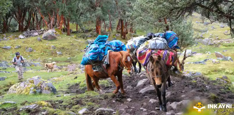
On the Lares Trek, cargo logistics fall to arrieros and mules. That operational difference changes the rhythm of camp life and distinguishes the route from the porter system used on the Inca Trail.
Close out the Lares Trek with a better-planned route
The Lares Trek works best when understood for what it actually is: a mountain route that combines altitude, living communities, lakes, hot springs, and a Machu Picchu close that needs to be locked in from the start. It does not have the Inca Trail’s permit bottleneck, but it should not be treated as a hike you can throw together at the last minute either. Choose the right version, review the package inclusions carefully, and arrive with reasonable acclimatization, and the trip becomes significantly smoother and more rewarding. If you want to sort all of that with real guidance and without getting lost in poorly explained options, contact us and we will help you put it together.
Frequently asked questions about the Lares Trek
Does the Lares Trek require a special permit?
No trail permit is required, unlike the Inca Trail. What does need to be booked is the Machu Picchu entrance ticket and, depending on how the program is structured, the train and entry time slot. In practice, the sensitive point is rarely the trail itself, but how well the final section of the trip has been resolved before you leave Cusco.
How far in advance should I book?
The route itself has more room than the Inca Trail, but that does not mean you should leave it to the last minute. If you are traveling between May and September, during holidays, or on high-demand dates, the most reasonable approach is to book 2 to 4 months in advance. In quieter months there may be more flexibility, but even then it is better to lock in the Machu Picchu entrance, the assigned circuit, and the train with time to spare.
Can it be done without a guide?
There may be variants where no strict prohibition exists, but for most it is not the best decision. Signage is not consistent, there are trail junctions that are easy to miss, weather shifts quickly, and altitude is unforgiving of simple mistakes. A guide does not only provide orientation. They help read the group’s pace, respond to altitude-related issues, and give real context to the route.
What is the real difference between the 4-day and 5-day versions?
The main difference is how you arrive at Machu Picchu. In the 4-day version, entry is handled from Machu Picchu Pueblo by bus with a regular ticket. In the 5-day version, the Short Inca Trail segment is added so that you walk in through Intipunku and pass sites like Wiñay Wayna along the way. The heart of the Lares Valley is present in both versions, but the close is quite different.
How many days should I acclimatize before the trek?
Two full nights in Cusco, or a reasonable combination that includes time in the Sacred Valley, should be treated as the minimum. Arriving and heading out the next day can work for some people, but it is not the smartest way to begin a route that passes through high-altitude terrain where the body is still adjusting.
How hard is the Lares Trek really?
It is not typically the most technical route to Machu Picchu, but that does not make it easy. The most demanding elements tend to be the altitude, the cold at night, the high pass, and the cumulative fatigue if you arrive poorly acclimatized. For someone with average fitness and basic preparation it can be a very manageable route. For someone who improvises everything, it can become unnecessarily punishing.
What happens if someone has altitude sickness?
A serious operator should carry a first-aid kit, supplemental oxygen, and staff with the judgment to decide when to act. The primary response to worsening symptoms is straightforward: assess, stop, and descend if necessary. In the mountains, the person who wins is not the one who pushes through out of pride. It is the one who knows when to keep going and when not to.
Are the Lares hot springs worth it or just a tourist add-on?
Worth it, for a very specific reason. After the high pass, the cold, and the wear of the first days, the warm water genuinely helps release the legs and back. It is not a spectacular luxury or the centerpiece of the route, but it is a functional stop that most people appreciate before moving into the rail section and the Machu Picchu close.
Is the Machu Picchu entrance automatically included in any package?
Do not assume it is. You need to check the service details and confirm not just whether the ticket is included, but also which circuit it covers and what time slot. Today it is not enough to read “Machu Picchu included.” That last day changes significantly depending on the type of ticket your operator has booked for you.
What is typically included and what is usually extra?
Most formal operators include the guide, transport, camping, trail meals, logistical support, return train, hotel in Aguas Calientes, and sometimes the Consettur bus. What tends to vary or be charged separately is the sleeping bag rental, trekking poles, train upgrades, single room supplement, Huayna Picchu Mountain ticket, and some minor expenses on the last day. That is why comparing the full package matters more than comparing a single price point.
What type of traveler fits this route best?
The Lares Trek fits well with travelers who want to hike in a less crowded environment, with more community presence and a more human experience overall. If your main priority is entering Machu Picchu on foot via a regulated archaeological route, the Inca Trail is a different proposition. If you want more dramatic mountain scenery and a higher volume of hiking, the Salkantay goes in another direction. Lares stands out when what you are looking for is a balance of landscape, altitude, living culture, and lower trail saturation.
Autor

Shared:


If you liked this article and the information you found, give us 5 stars!
 (1 votos, promedio: 5.00 de 5)
 Loading...